Where was ancient Egypt located on a map?
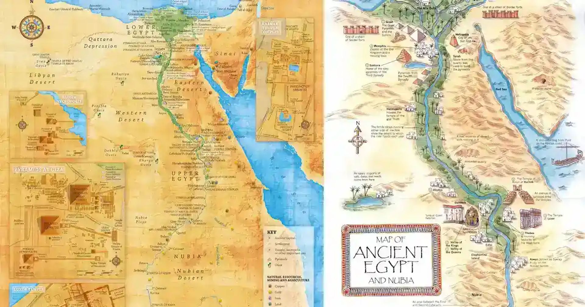
Ancient Egypt was located in northeastern Africa along the Nile River, where a narrow strip of fertile land ran between deserts. An ancient Egypt borders map places the country from the Mediterranean Sea in the north to Nubia in the south, with the Sahara on the west side and Sinai on the east side. That river corridor is the core of every old Egypt map.
The Nile gave ancient Egypt water, farmland, and a travel route that linked towns and temples. The surrounding desert limited settlement and made the river valley the center of daily life. When you read the map of ancient Egypt, you are really reading a map of controlled land, not open country.
What did the Old Kingdom Egypt map include?
The Old Kingdom Egypt map usually includes Upper Egypt, Lower Egypt, Memphis, Giza, Saqqara, and Dahshur. The Old Kingdom ran from c. 2686 to 2181 BCE, and its map matters because it shows the political center of pyramid building and the main route used to move people and stone along the Nile.
Memphis sat near the meeting point of Upper and Lower Egypt, so it worked well as a capital. Giza, Saqqara, and Dahshur all sit close to the west bank of the Nile, where royal tombs aligned with beliefs about the setting sun and the afterlife.
- Memphis, the administrative center of the Old Kingdom
- Giza, home to the Great Pyramid complex
- Saqqara, the site of the Step Pyramid of Djoser
- Dahshur, known for the Bent Pyramid and Red Pyramid
How did the Nile shape ancient Egypt borders?
The Nile shaped ancient Egypt borders by creating a long, narrow zone of settlement with fixed natural edges. Ancient Egypt depended on the annual flood cycle, which left fertile silt in the valley and delta. The river also acted as a transport spine, so political control followed the water north and south.
A map of old Egypt shows the Black Land, the fertile strip beside the Nile, and the Red Land, the desert beyond it. That contrast explains why towns, farms, and major monuments cluster near the river while most surrounding land stayed empty or lightly used.
What do ancient Egypt trade routes look like on a map?
Ancient Egypt trade routes map out connections to Nubia, Sinai, the Levant, and possibly Punt. These routes matter because Egypt needed gold, copper, turquoise, timber, and incense that the Nile Valley did not provide on its own. An old Egypt map is also a trade map.
The eastern routes reached Sinai mining areas, while southern routes reached Nubia. Northern contact moved toward the Mediterranean world. Trade was never random, because geography funneled movement through river crossings, desert roads, and ports on the Nile or Red Sea.
How does an old Egypt map help travelers today?
An old Egypt map helps travelers place modern sites inside ancient geography. Giza sits near Cairo, Luxor matches ancient Thebes, and Aswan marks Egypt's southern reach. Once you see those points together, the country stops feeling abstract and starts making geographic sense.
Travelers also use the map to plan smarter routes. Cairo pairs well with Giza and Saqqara, while a Nile cruise shows the river corridor that tied ancient Egypt together. Visitors who understand the map usually get more out of each site because they know why it was built there.
- Start in Cairo for Giza and the Egyptian Museum area.
- Add Saqqara and Memphis in the same day if you want the Old Kingdom story.
- Use a Nile cruise to follow the north south route that shaped ancient travel.
- Visit the west bank sites with the afterlife beliefs in mind, especially around Luxor and Giza.
What is the difference between Upper and Lower Egypt?
Upper Egypt is the southern part of the country, and Lower Egypt is the northern delta region. The names follow the direction of the Nile, not a simple north south label. Because the river flows from south to north, Upper Egypt is upstream and Lower Egypt is downstream.
That division matters on any map of ancient Egypt because it explains early politics and later unity. Before unification under King Narmer around 3100 BCE, these regions had their own identities. After unification, the two lands became the basis of royal ideology and state control.
Plan with us
Ancient Egypt borders: an old Egypt map guide
See where ancient Egypt was located, how the Old Kingdom borders worked, and why the Nile shaped cities, trade, and pyramids.